CLAYTON — Rabun County has been hard hit by rainfall from subtropical depression Alberto in recent days.
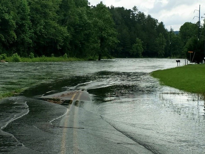
The accumulation of nearly eight inches of rain in the past 48 hours caused treacherous conditions as lake and river bodies spilled over onto local roadways. As a result, Georgia Power Co. will continue to release excess water from Lake Burton Dam, Lake Rabun/Mathis Dam, Tallulah Falls Lake and Dam and Lake Tugalo Dam.
Although the majority of rainfall has stopped, these releases — combined with the preexisting high water conditions on feeder streams, especially on Tiger Creek — is causing rapid rises downstream of Mathis Dam. Floodwaters have closed Shady Lane and are threatening Joy Bridge Road among other roads downstream of these lakes.
“Shady Lane and Mathis Dam Road are still flooded,” said Rabun County Emergency Management Agency Director Michael Mazarky on Thursday. “It’s come up more since last night. There’s also a portion of Old 441 that the water has started to cover, and we’ve had a couple of trees come down around Laurel Lodge this morning.”
Elsewhere across the county, minor flooding of several secondary roads is ongoing. The Tallulah River above Lake Burton remains elevated. The Chattooga River also is elevated at this time.
Mazarky urges the public to please avoid all flooded roadways and not to drive around barricades.
“We are still urging people from staying off the roads and not go around the barricades because we’re not sure of the conditions of the road up underneath the water,” Mazarky said. “So, we need to keep people off from trying to drive on those roads.”
Mazarky said the ground is so wet from the heavy rainfall that mudslides are possible near steep terrain. The mudslide can consist of rock, mud, vegetation and other loose materials and are very powerful.
“The ground is so wet already that any more rain or a little bit of wind and these trees could start going down,” Mazarky said. “It could definitely cause the banks to slide. I think there was one [mudslide] out there on 76 toward the Towns County line where it started to slide but it didn’t get on the road,” he said.
Some locations that may continue to experience flooding include Clayton, Mountain City, Tiger, Dillard, Sky Valley, Lake Rabun, Lake Burton, Moccasin Creek State Park, Lakemont and Tallulah Gorge State Park.
Shady Lane, Joy Bridge Road, Mathis Dam Road, and Old 441 all may be impacted, and portions of these roads may still be flooded.
“The lake levels that I saw this morning when I was out, Shady Lane is still flooded,” Mazarky said. “Mathis Dam Road is still flooded — it’s come up more since last night, or higher on the road.”
Campgrounds, lake and river access points, and other low-lying areas along the Tallulah River between Lake Burton and Tallulah Gorge will continue to be threatened by floodwaters.
“We’re going to continue to watch the weather and hopefully the water levels are going to start going down, but it’s going to take them a while,” Mazarky said. “There is just so much water and it’s still coming off from the tops of the mountains. It hasn’t really hit the lakes yet either. So, we just ask people to bear with us and we will get through this.”
Here are some recommended actions to help keep people safe until the flooding danger has passed:
- Most flood deaths occur in vehicles. Do not attempt to cross water-covered roadways, bridges, or low-level crossings. Only a few inches of rapidly flowing water can carry away your vehicle. It is not worth the risk.
- Excessive runoff from heavy rainfall is causing flooding of small creeks and streams, country roads, as well as farmland, drainages, and other low-lying areas.
- The previous rounds of heavy rain have increased the risk of landslides, especially in areas where slides have occurred in the past. Be especially alert if you are near a stream, especially at the base of a mountain or in a cove. Watch for loose-moving soil and rocks or a sudden increase in streamflow. Leave the area quickly if this is observed. When driving along roads where the terrain is steep or rocky, watch and listen for falling rocks, mud, trees and other debris.