UNDATED - Sixteen counties in north Georgia - including Hall - are now under a Flash Flood Warning as torrential rains continue across the region.
The National Weather Service (NWS) says another 2-3 inches of rain is possible in the affected counties through this morning. By 10:00, rainfall at the Gainesville airport, since midnight, totaled about 3.5 inches... nearly 4 inches since the rain started yesterday. The affected counties and others in north Georgia are also under a Flash Flood Watch.
NWS hydrologist Kent Frantz said Big Creek in Alpharetta was 0.3 inches above the 7.0 flood stage at midmorning and should crest at about 8.3 feet Wednesday evening.
Frantz said, ``We are monitering a bunch of creeks and rivers in north Georgia.'' He said the rain fell at a clip of about one-third inch overnight and ``we are looking at another 2 to 4 inches on top of what has already occurred. It is exactly what north Georgia needs with a drought. It's a soaker situation.''
There have been reports that Clay Creek Falls Road in Lumpkin County has been flooded by water from a nearby pond. Officials are closely monitoring the Etowah River in Forsyth and Dawson counties for flooding and a close watch is being kept on Crooked Creek in Banks County near The Pottery Barn.
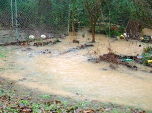
Hall County Emergency Management Agency Director David Kimbrell says "creeks are swollen" in Hall County but so far there are no reports of significant flooding. Kimbrell said the rain has been steady enough that it is "running off" without creating a problem. He says there is no "magic number" when it comes to how much rain can fall before there are problems. Even ten inches of rain is manageable, he said, if it falls at a steady rate over a period of time. However, he says, ten inches in two hours will create flash flooding.
TEXT OF FLASH FLOOD WARNING:
940 AM EST TUE JAN 6 2009
THE NATIONAL WEATHER SERVICE IN PEACHTREE CITY HAS ISSUED A
COUNTY FLOOD WARNING FOR URBAN AREAS AND SMALL STREAMS IN...
DAWSON COUNTY IN NORTH CENTRAL GEORGIA
FANNIN COUNTY IN NORTH CENTRAL GEORGIA
HALL COUNTY IN NORTH CENTRAL GEORGIA
LUMPKIN COUNTY IN NORTH CENTRAL GEORGIA
UNION COUNTY IN NORTH CENTRAL GEORGIA
BANKS COUNTY IN NORTHEAST GEORGIA
TOWNS COUNTY IN NORTHEAST GEORGIA
WHITE COUNTY IN NORTHEAST GEORGIA
UNTIL 930 AM EST WEDNESDAY
AT 925 AM EST...OCCASIONAL MODERATE TO HEAVY RAIN CONTINUES OVER
THE WARNED AREA. RAINFALL AMOUNTS OF 2 TO 3 INCHES HAVE ALREADY
OCCURRED AND ANOTHER 2 TO 3 INCHES IS EXPECTED THROUGH WEDNESDAY
MORNING.
MANY STREAMS AND CREEKS ARE RISING RAPIDLY AND SOME MAY HAVE
ALREADY SPILLED OUT OF THERE BANKS. EMA OFFICIALS HAVE REPORTED
NUMEROUS DRAINAGE PROBLEMS ON ROADS DUE TO DEBRIS BLOCKAGE.
WIDESPREAD MINOR FLOODING OF CREEKS AND RIVERS IN THE WARNED AREA
ARE EXPECTED.
EMA OFFICIALS ARE REQUESTED TO MONITOR RIVERS...STREAMS AND CREEKS
IN THE WARNED AREA FOR FLOODING...SUCH AS CROOKED CREEK IN SOUTH
BANKS COUNTY NEAR THE POTTERY BARN.
DO NOT ATTEMPT TO CROSS WATER OF UNKNOWN DEPTH...ON FOOT OR IN AN
AUTOMOBILE. DO NOT DRIVE AROUND BARRICADES...MOST FLOOD DEATHS OCCUR
IN AUTOMOBILES. DO NOT STAY IN AREAS SUBJECT TO FLOODING WHEN WATER
BEGINS RISING.
STAY TUNED TO WEATHER RADIO OR LOCAL MEDIA FOR FURTHER STATEMENTS OR
WARNINGS.
IF YOU SEE SIGNIFICANT FLOODING...WAIT UNTIL AFTER THE STORM HAS
PASSED...AND THEN CALL THE NATIONAL WEATHER SERVICE TOLL FREE AT 1-866-763-4466.
(AccessNorthGa.com's Ken Stanford and Judd Hickinbotham contributed to this story.)
Thursday
July 3rd, 2025
9:20PM