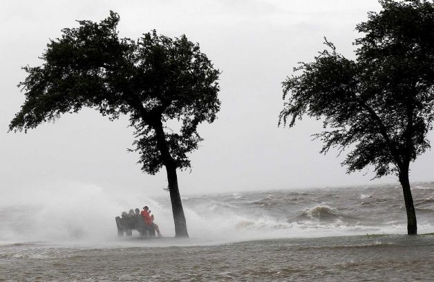
NEW ORLEANS - Hurricane Isaac pushed water over a rural levee to flood some homes, knocked out power and immersed beach-front roads in Louisiana and Mississippi early Wednesday as it began a drenching slog inland from the Gulf of Mexico with a newly fortified New Orleans in its path. Meanwhile, the U.S. Army Corps of Engineers says that, so far, the levees at New Orleans are holding.
Wind gusts of more than 60 miles per hour and sheets of rain pelted New Orleans, where people braced themselves for the storm behind levees that were strengthened after the much stronger Hurricane Katrina hit seven years ago to the day.
Officials say New Orleans' flood protections system were holding up so far as Hurricane Isaac storms through the area; the rural levee was not part of the new system.
"The system is performing as intended, as we expected; we don't see any issues with the hurricane system at this point," said Army Corps of Engineers spokeswoman Rachel Rodi.
She said the corps expected to be on "high alert" for the next 12 to 24 hours.
Isaac's dangerous storm surges and flooding threats from heavy rain were expected to last all day and into the night as it crawls over Louisiana, the U.S. National Hurricane Center in Miami warned.
Water driven by the large and powerful storm pushed over the top of an 18-mile stretch of one levee in Plaquemines Parish south of New Orleans, flooding some homes in a thinly populated area. The levee is one of many across the low-lying coastal zone and not part of New Orleans' defenses.
As the rain continued and winds pushed across the Gulf Coast, it remained far too soon to determine the full extent of the damage.
Authorities in Plaquemines Parish believe some people may be trapped but were not sure how many may have remained despite an earlier evacuation order. Rescuers were waiting for the strong winds to die down later in the day before moving out to search.
"We did have two parish police officers that were stuck in a car there. We just found out they were rescued and are safe," said emergency management spokeswoman Caitlin Campbell. Two other parish workers in a boat rescued them.
Isaac was packing 80 mph winds, making it a Category 1 hurricane. It came ashore at 7:45 p.m. EDT Tuesday near the mouth of the Mississippi River, driving a wall of water nearly 11 feet high and soaking a neck of land that stretches into the Gulf.
The storm stalled for several hours before resuming a slow trek inland, and forecasters said that was in keeping with the its erratic history. The slow motion over land means Isaac could be a major soaker, dumping up to 20 inches of rain in some areas, and every storm is different, said Ken Graham, chief meteorologist at the National Weather Service office in Slidell, La.
"It's totally up to the storm," he said.
Isaac's winds and sheets of rain whipped New Orleans, where forecasters said the city's skyscrapers could feel gusts up to 100 mph. The weather service said more than 9 inches of rain had fallen in New Orleans in the 24 hours up to 7 a.m..
Power was knocked out to 482,000 customers across southern Louisiana, about 157,000 of them in New Orleans, utility Entergy said.
In Mississippi, the main highway that runs along the Gulf, U.S. 90, was closed in sections by storm surge flooding. At one spot in Biloxi, a foot of water covered the in-town highway for a couple of blocks and it looked like more was coming in. High tide around 9:30 a.m. was likely to bring up more water.
In Pass Christian, a Mississippi coastal community wiped out by hurricanes Camille and Katrina, Mayor Chipper McDermott was optimistic Isaac would not deal a heavy blow.
"It's not too bad, but the whole coast is going to be a mess," he said early Wednesday.
Tuesday
July 15th, 2025
9:52PM