UNDATED - Rainfall in Gainesville has topped five inches for the month - only the second monthly total of five or more inches since last July. And, the National Weather Service (NWS) says drought conditions should improve for northeast Georgia between now and May.
The NWS's Southeast River Forecast Center has released a drought update, detailing where we stand with Georgia's worst-ever drought as we head into spring.
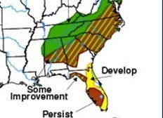
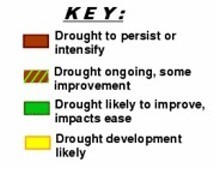
According to the report, the area of north Georgia north of a line from near Rome to Tallulah Falls can expect the drought to "improve (and the) impact to ease."
In most of the rest of the state, in an area which which includes Gainesville, the NWS says expect the drought to continue but "with some improvement." The southeast corner of the state and a bit of southwest Georgia appear out of the woods for now.
Even with the rainy January Gainesville has experienced, officials say March will be the key to how well we do this summer.
By 12:30 Friday afternoon, the Gainesville airport had picked up 1.18 inches of rain since the current rainy spell started Thursday, bringing the monthly total to 5.41 inches. The last time the airport recorded more than five inches for one month was last July when 5.21 inches were recorded.
Hydrologist Todd Hamill says if we can raise the huge reservoirs, such as Lake Lanier, by five-to-seven feet then "we'll have something to work with." By late Friday morning, the level of Lanier was continuing to climb and was at 1053.07. It has continued to rise since January 10 when it was at 1051.18.
TEXT OF U.S. SEASONAL DROUGHT OUTLOOK FROM THE NATIONAL WEATHER SERVICE:
The northern part of the Southeastern drought region should continue to see improvement, while the odds for drought relief by the end of May diminish farther south, resulting in more limited improvement from central Alabama into the Carolinas and southeastern Virginia.
A continuation of a stormy pattern for at least the latter part of February will result in beneficial moisture for most of the drought region. In contrast, the odds favor above-normal temperatures and below-normal rainfall during March-May across the Southeast, so there is a good chance that conditions will deteriorate following the near-term improvement.
Even where improvement is anticipated, many reservoirs and wells will remain low due to lingering impacts from the extreme rainfall deficits incurred last year. Elsewhere, developing drought remains likely across the southern Plains from central Texas into eastern and southern New Mexico and northward into southwestern Nebraska.
Consistent with the persisting La Niña episode, medium and long-range forecasts indicate below-normal rainfall for this region. Year-to-date rainfall through February 19 was less than 25 percent of normal in parts of southeastern New Mexico and southern and western Texas. In the Northern Plains, drought is expected to persist from southwestern North Dakota into western Nebraska, with some improvement to the north and west, and more substantial improvement over the Great Basin.
Lingering drought may persist in southern California and southwestern Arizona due to a dry pattern forecast for March-May.
......
On the Net:
NWS Drought Information Center. http://www.drought.noaa.gov/
Wednesday
April 30th, 2025
12:31AM