It will require the closure of Forest Service roads and trails adjacent to and within the Jake and Bull Mountain Trail System. The following closures will take effect at 7:00 a.m. and last until 6:00 p.m.
Road Closures:
FS Road 77 (Winding Stair Gap Road)
FS Road 77A
FS Road 877
FS Road 28-A
FS Road 141 (Penn Cove Road)
Trail Closures:
223K north of FS Road 28-1
223P north of FS Road 28-1
223L east and north of FS Road 77
The Springer Mountain trailhead will remain open. Alternate access to Springer Mountain can be obtained by traveling north on Business Highway 19 to Camp Wahsega Road. Turn left on Camp Wahsega Road for approximately 9 miles to the intersection at Camp Frank D. Merrill. Turn right onto Forest Service Road 80; go approximately three miles to intersection with Forest Service Road 42. Turn left on Forest Service Road 42; go approximately ten miles to Springer Mountain parking lot on right. The Appalachian Approach Trail that begins at Amicalola Falls State Park will also remain open.
The Forest Service says it uses controlled burns when conditions are just right to reduce the amount of vegetation and woody debris on the ground that could contribute to catastrophic wildfires, and also to reduce the risk of damage to the forest and neighboring property in the future. The burns also make the forest healthier and improve wildlife habitat because of the high nutritional value of the new growth that will take place this spring and the more open conditions in the forest.
For more information concerning these controlled burns or to view maps for the proposed burn areas, visit the Chattahoochee-Oconee National Forest website at www.fs.usda.gov/goto/conf/fire, or contact the Blue Ridge Ranger District Office at 706-745-6928. A free app that provides instant alerts for the national forest is also available for smart phone users by visiting the Forest's website at www.fs.usda.gov/conf.
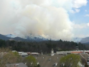
Juber Know controlled burn as seen from Blairsville March 2010. (Photo courtesy USFS)
http://accesswdun.com/article/2014/2/271754