In the research, which is funded by the National Aeronautics and Space Administration (NASA) and the National Science Foundation, the team redefines the term Urban Climate Archipelago (UCA). UCAs are formed by chains of urban areas that have a cumulative impact on the climate surrounding them. The definition proposed by the team is unique among its predecessors in its scope and more clearly defined link to climate processes. The team also plans topics for further research, including the global or regional distributions of UCAs and the thermal impacts of UCAs on weather and climate.
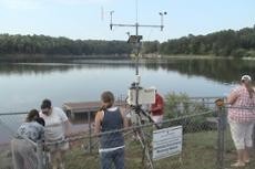
The research links to work by Strother and other researchers with IESA in hopes of improving the understanding of the environment in and around northeast Georgia, including Lake Lanier and changes in urban climate.
"IESA serves an important role in the region and at UNG by providing students with interdisciplinary educational and research opportunities that couple technical and spatial skills to engineering and the physical and social sciences," said Dr. Jeff Turk, IESA director. "The institute is a vibrant and vital asset that helps shape the future by providing students a robust intellectual environment, dynamic problem-solving skills and holistic educational experiences that distinguish our students and facilitates the success of our graduates."
The institute is involved in several projects across northeast Georgia, including one involving Lake Lanier, one of the state's most important resources. Researchers are combining decades of qualitative and quantitative data to construct a more accurate record of the lake and its changes over the years. On the north end of Lanier, the institute and other affiliated faculty are beginning a multi-disciplinary study and trail design project with Don Carter State Park, Strother said.
"IESA has helped map the Atlanta Botanical Gardens as well as the new Linwood Nature Preserve in Gainesville," Strother said. "Our students regularly process and interpret land-use change throughout the region using advanced remote-sensing and object-based image analysis techniques. In the social sciences, we use Geographic Information Systems (GIS) technology to study crime patterns, public health concerns, environmental management, and to help inform policy makers through our environmental studies concentration."
The institute is a hub for undergraduate research, with students and faculty collaborating on research that is often cross-disciplinary. Projects so far have included tracking and mapping the locations of box turtles on UNG's Gainesville Campus, mapping locations of sampling sites for biology and environmental science students, and monitoring water quality and pollution in Hall County watersheds.
"The biggest contribution IESA is making to UNG is its focus on encouraging undergraduate research," Strother said. "I know from my own experience as a graduate of UNG that I felt well-prepared for the rigors of my master's program at the University of Georgia. Former graduates of the Applied Environmental Spatial Analysis program have told me that they are usually seen as 'go-to' employees almost immediately after entering the workforce."

http://accesswdun.com/article/2014/2/271252
