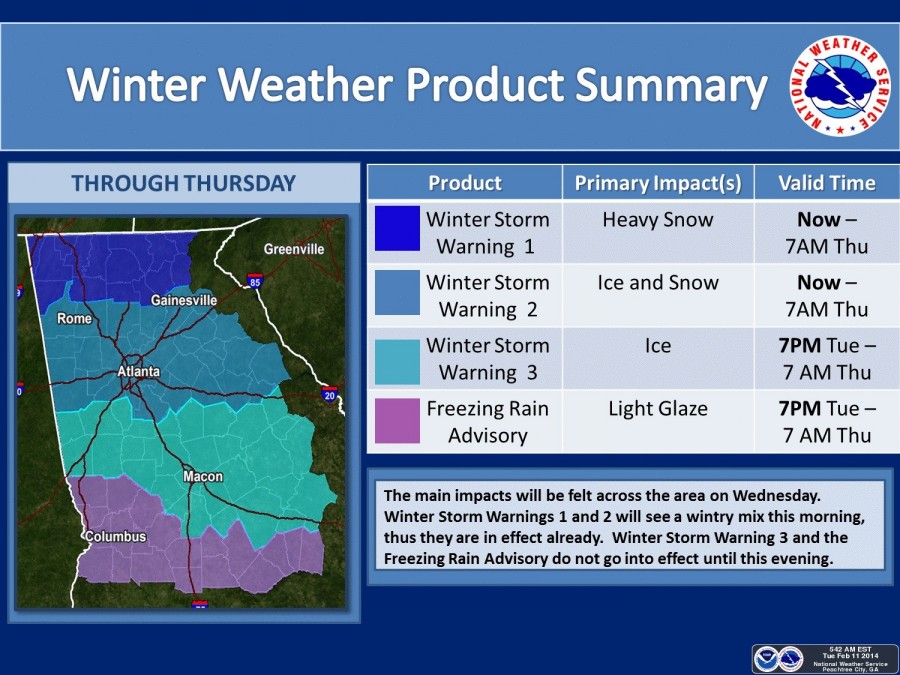
Click on the link below or the accompanying graphic to view the areas of the state referenced in the following message from NWS's Jessic Fieux which was issued shortly before 9:00 this morning:
"We've had reports of snow and sleet across north Georgia this morning - mainly north of a Atlanta to Athens line. Will see a snow/sleet combination continue into the morning. Some of this may transition to rain during the afternoon. Accumulation with this mornings event should be up to an inch with isolated areas as high as 2. Please keep up to date with our forecast as this could change - NWS Chat is a great way to know the latest. Keep in mind, even if you don't end up seeing accumulation today, please don't let your guard down - tomorrow is the more significant/high impact day.
Warnings/Advisories...
We know that this is a complicated warning situation in terms of products and here's our thinking. I'll be referring to the attached graphic for areas.
Winter Storm Warning 1: This is a continuation of the Winter Storm Warning. It was expanded in time and now goes through 7am Thursday morning. Could see up to an inch today of snow with isolated areas of up to 2 inches. Significant impacts possible today, but the greater threat remains tomorrow. 5 to 7 inches of snow tonight through Wednesday night with localized amounts of up to 9 inches across the northeast.
Winter Storm Warning 2: This is the most complicated area and yes it includes Atlanta. Part of this area was already in the warning. Part of this area was in the advisory but has now been upgraded to a warning. We decided not to go with the advisory for today and start the warning tonight but instead we started the warning this morning for the ATL metro area for simplicity.
Please keep in mind though, that the southern portion of this area may see all rain today (could see a little mix of sleet in there for this morning) and we really aren't expecting to see much in the way of accumulations - no accumulation for the very southern portion of this area. For those in this Winter Storm Warning 2 area that were NOT in the advisory previously...you should only see rain today and won't start seeing the winter weather until tonight. Please do not focus on the fact that you are now in a warning that starts today - winter wx should hold off until tonight.
You are in this grouping because it aligns better with the combination of snow and ice expected for your area. If you have any concerns that you are in the Winter Storm Warning that is in effect now please call us and we can better explain the impacts for today. Could see a catastrophic ice accumulation across the south and eastern portion of this area.
Winter Storm Warning 3: This area was in the Winter Storm Watch and has been upgraded to the Winter Storm Warning. This goes into effect tonight at 7pm but the most significant amounts and impacts will be during the day Wednesday. Catastraphoic ice accumulation in some of this area. Highest amounts are on the east side of the state. Primary threat is ice. Could see some snow mixed in for the northern portion of this area at the end of the event.
Freezing Rain Advisory: A few of the counties in this area were in the Winter Storm Watch, but most weren't. A light glaze of ice on roadways is possible. In effect 7pm tonight to 7am Thursday.
Tone alerting of Winter Storm Warning - Since we upgraded the Winter Weather Advisory to a Winter Storm Warning but for the impacts tonight and tomorrow rather than the impacts today, we are holding off on tone alerting NOAA Weather Radio for the Winter Storm Warnings that are out. This will be done later this morning.
This still remains a complicated situation given all of the different precipitation types and the products."
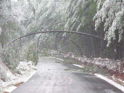
Do you remember the ice storm of January 23, 2000? This picture shows what many parts of north Georgia looked following that storm. 1/4 to 1/2 inch of ice caused 300,000 residents to lose power that day. Tree cleanup lasted for months. NWS is curren
http://accesswdun.com/article/2014/2/271025