"Increasing Georgia's role as a global hub for freight and logistics requires us to prioritize limited resources toward the most critical roads and interchanges," Gov. Nathan Deal has said. "This designated freight corridor does just that, and I appreciate the cooperation we've had with the GDOT Board and the General Assembly to bring this plan to fruition."
The five northeast Georgia roads are: I-85 from Atlanta to the South Carolina line; I-985 from Suwanee to Gainesville; U.S. 441 through Commerce, Habersham County and Clayton, to the North Carolina line; and Georgia 17 in the Toccoa, Hartwell, Elberton areas.
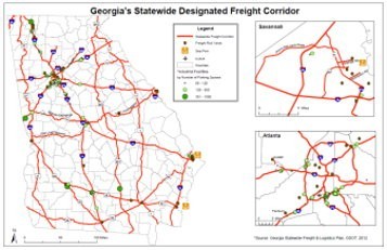
The full map of the designated state Freight Corridor Network is posted at http://www.dot.ga.gov/freight and highlights the key strategic highway routes that handle the flow of freight to and from locations in Georgia. House Bill 202, signed into law this past legislative session, allows for roads on the freight corridor network to be exempted from Congressional Balancing related to transportation dollars spent on the routes.
DOT says the plan identified the 50 highest truck volume locations and the most critical freight bottlenecks throughout the state.
"The Freight Corridor Network was identified through technology, data collection and discussions with leaders in the logistics industry," GDOT Board Chair Jay Shaw notes. "We studied the situation and determined the most important areas of improvement to help keep freight moving and keep Georgia at the top of economic development efforts. We worked closely with the Georgia Ports Authority and the Center of Innovation for Logistics to ensure we incorporated future projections and needs for freight movement."
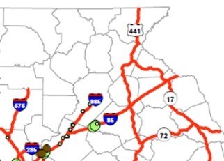
Northeast Georgia portion of the freight corridor (Map from GDOT)
http://accesswdun.com/article/2013/8/264666